Miami County file review
Authority, identity, condition, access, configuration, equipment, custody, capacity, reporting, and destination remain assignment-specific.
A five-factor screen for Louisburg lender files
Coverage for Louisburg, Kansas does not require inference from a radius map; LRS includes the municipality in its lender-recovery area. Banks, credit unions, automotive finance companies, BHPH lenders, servicers, forwarders, and other authorized secured parties can screen a Louisburg or southern Miami County file before protected information changes hands. Start with five facts: broad location, collateral class, access setting, transport direction, and destination. LRS then decides whether the request can move to secure intake, needs an equipment or transport review, or requires a different coverage decision.
Service-area coverage only. The documented recovery on this page establishes completed Louisburg work without implying an office, staffed storefront, public facility, local storage yard, daily local operation, dedicated unit, guaranteed timing, or guaranteed outcome.
Local fit without a detour
LRS provides a direct municipal coverage answer for Louisburg, Kansas: authorized lender recovery inquiries are within scope. A new assignment still must establish its own authority, access, equipment, and destination facts.
For a concrete Louisburg reference point, the approved recovery involved a 2019 livestock trailer near a farmstead with machinery positioned around a machine shed. The file changed when the collateral was non-running and required a different movement plan than originally anticipated. That is the kind of assignment-specific fact a lender should surface before protected data is exchanged.
A lender should provide only enough public context to make the request answerable: institution, authorized contact, broad city or county, asset family, general condition, access category, and destination. The secure handoff follows after LRS confirms the file’s operational fit. A lender can sharpen the Louisburg review by applying this local instruction: Identify the institution, authorized business contact, Louisburg or Miami County, broad collateral class, high-level condition and access setting, and intended destination.
Authority, identity, condition, access, configuration, equipment, custody, capacity, reporting, and destination remain assignment-specific.
Use business identity, broad geography, collateral family, general condition or access, and destination type; keep protected file data in the approved secure channel.
Louisburg, Kansas is within LRS coverage for authorized lender repossession and collateral-recovery inquiries.
A completed livestock trailer recovery supplies city-specific operating evidence without exposing the lender, consumer, identifier, or exact address.
Coverage is already confirmed: Contact LRS to evaluate the individual assignment—not merely to ask whether Louisburg is served. Public contact must exclude debtor, account, VIN, serial, plate, exact-location, access-code, credential, and legal-document data.
Documented local recovery
A lender assignment in Louisburg, KS involved the recovery of a financed 2019 livestock trailer located near a farmstead with machinery positioned around a machine shed. Before movement, the recovery agent confirmed the secured-party assignment and positively identified the trailer through the lender’s approved information. The collateral was non-running and required a different movement plan than originally anticipated.
The agent photographed visible condition, checked available clearance, and adjusted the recovery method to the equipment and surroundings present. Agricultural collateral repossession in Louisburg, KS can involve trailers, trucks, tractors, and other secured equipment throughout Miami County. Once a workable recovery path was established, the livestock trailer was connected and secured appropriately.
The Louisburg recovery was completed successfully, and the collateral was transported to Lenders Recovery Service for secure storage. Post-recovery photographs documented condition and custody before the lender was notified that the asset had been recovered.
This documented account omits the lender, consumer, account, VIN or serial number, exact recovery address, and protected field instructions.
The Louisburg decision model
This page does not use a road list as a stand-in for operating experience. It gives an authorized creditor a practical way to describe the assignment without exposing a debtor, account, VIN, serial number, exact location, access credential, or live field instruction.
The screen begins with broad geography and ends with the receiver. Each answer changes the equipment, custody, transport, or acceptance review. A category appearing here means it can be evaluated; it does not promise capacity for a particular unit.
Louisburg city limits, another Miami County community, or unincorporated Miami County—without publishing a precise address.
Passenger vehicle, pickup, commercial unit, trailer, recreational asset, farm or construction equipment, or custody-transfer file.
Paved parking area, residential drive, acreage entrance, gravel approach, jobsite, equipment yard, or staffed custody location.
The general direction or distance band to the next custody point, stated without treating a highway name as the operating plan.
The authorized receiver type—lender, storage, auction, dealer, service location, or another approved handoff point.
Asset-and-access tool
Choose the row closest to the file, then supply the five decision facts at a non-sensitive level. LRS uses those facts to determine whether a standard vehicle review, specialty-equipment review, custody coordination, transport planning, or a different next step is appropriate.
| Starting situation | Broad location | Collateral and condition | Access setting | Transport direction | Destination |
|---|---|---|---|---|---|
| In-town vehicle | Louisburg city limits | Passenger vehicle, pickup, SUV, or van; running status, keys, driveline, visible damage | Street, driveway, parking area, garage constraint, gate, or other high-level access condition | State the general direction of onward movement | Identify the authorized receiver and its intake constraints |
| Acreage or county-road vehicle | Unincorporated or rural Miami County; name the broad area only | Road-going collateral; condition, tires, mobility, keys, and any attachment | Paved or gravel approach, grade, soft ground, gate, turning room, overhead or loading constraint | Flag the distance band and whether a transfer point may be needed | Confirm storage, auction, lender, dealer, or other approved receiver |
| Farm or construction unit | Louisburg-area farm, acreage, equipment yard, or jobsite at a non-precise level | Asset type, approximate dimensions and weight band, tires or tracks, steering, attachments, mobility | Surface, grade, loading room, turning space, gate width, overhead clearance | Describe the desired movement direction before equipment is selected | Provide receiver loading, appointment, securement, and delivery requirements |
| Trailer, RV, boat, or commercial unit | City or county setting and present custody type | Configuration, axle or hitch details, load status, approximate dimensions, tires, brakes, mobility | Lot size, coupling access, turning space, surface, obstruction, and loading condition | Identify whether the unit moves directly or through an approved transfer | Name the receiver type and any appointment, dock, gate, or acceptance rule |
| Impound-held or voluntary collateral | Broad custody location in or around Miami County | Unit class, keys, condition, release status, holds, fees, and known movement limits | Staffed facility, scheduled handoff, legal release, or other custody condition | Define the authorized onward movement after release | Confirm who may receive the asset and what documentation the receiver requires |
Verified geography, limited purpose
Kansas Department of Transportation materials identify K-68 at Louisburg and the connection near U.S. 69; KDOT's Miami County expansion page describes the K-68 segment from U.S. 169 to Spring Valley Road just west of U.S. 69. Miami County publishes a county road map and describes maintenance of both gravel and paved roads. Those sources support only a broad city, county, corridor, and surface-setting screen.
They do not prove that LRS has completed a Louisburg recovery, follows a daily route, monitors a corridor, knows a private property, or can reach a file within a stated time. Likewise, the City's Police Department page identifies the current municipal agency context, not a standing repossession procedure, endorsement, or file instruction.
Official sources: KDOT K-68 expansion in Miami County · Miami County GIS and road map · Miami County Road & Bridge · City of Louisburg Police Department
Decision point
The purpose of the first contact is to reach the correct next decision—not to place protected assignment data into a public channel.
The broad location, collateral class, access setting, transport direction, and destination are clear enough for LRS to decide whether to invite protected file data through the approved channel.
Review the next-step guidanceA non-running unit, specialty configuration, acreage approach, limited loading area, long movement, or receiver rule needs a separate capability and cost review before acceptance.
Review the next-step guidanceA city name or route reference by itself is not enough. LRS may need a better broad-area description or a missing decision fact before it can confirm fit.
Review the next-step guidanceKansas legal boundary: Kansas Statutes §84-9-609 permits nonjudicial possession after default only when it proceeds without breach of the peace. Authority, current law, client instructions, reporting, and the circumstances of an accepted assignment still require file-specific review. This page is operational information, not legal advice.
Proof and media gates
The two requests are separate so a photograph cannot be mistaken for a completed case record and a case record cannot establish ownership or provenance for an image.
The documented recovery on this page matches Louisburg and records a completed outcome. The public account withholds the client, consumer, account, VIN, plate, precise location, access instructions, and protected investigative details.
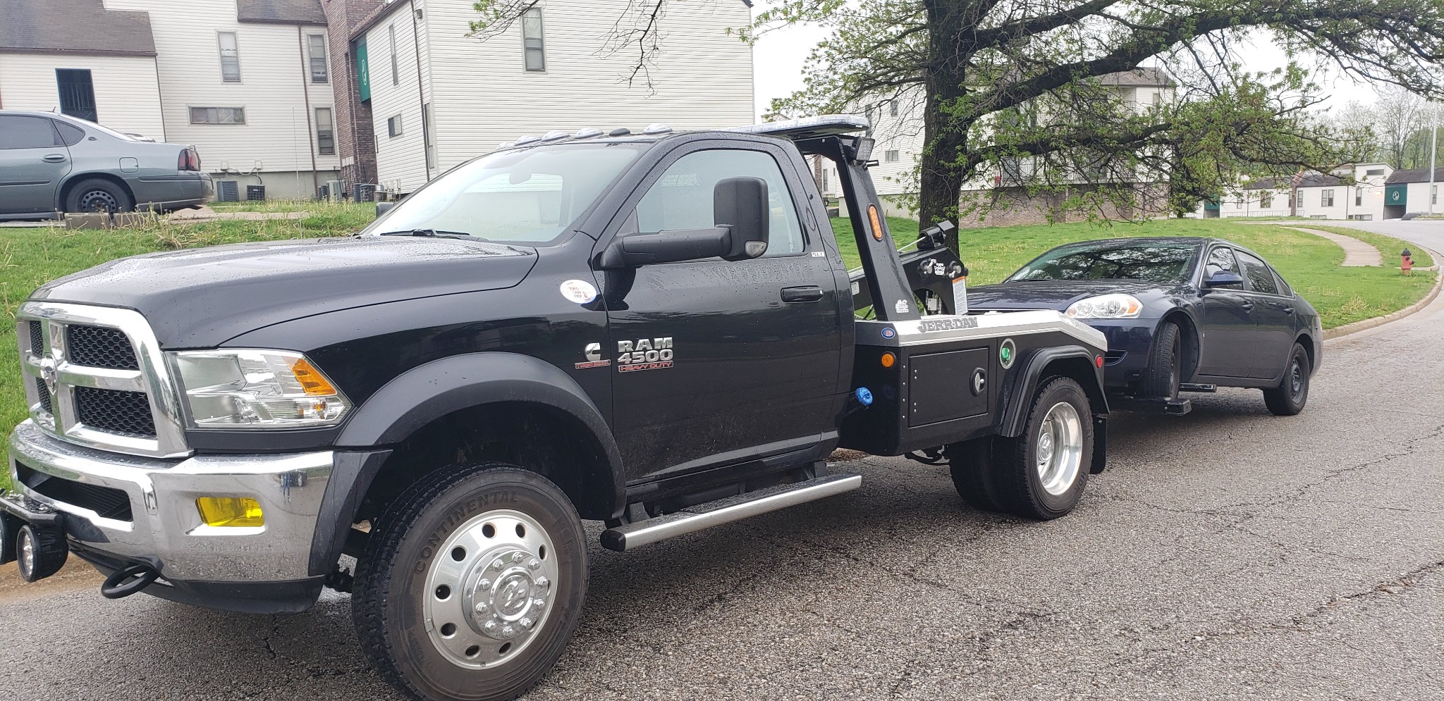
The user-supplied JPEG is matched to Louisburg at the city level, depicts a passenger vehicle positioned with a self-loading recovery truck, and contains no legible plate, person, account identifier, or exact address. Its 2,048 × 995 dimensions are preserved in the markup. The image supports local field and equipment context only; it does not establish the final assignment outcome.
Approved local media
The photograph confirms local field activity and shows the passenger-vehicle and self-loading-truck context behind one row of the screening matrix. It helps a lender understand why collateral class, running condition, available positioning space, surface, and destination still matter even when the asset is a conventional road-going vehicle.
The photograph does not identify the client, consumer, account, VIN, plate, exact location, assignment stage, or final outcome. It also does not prove daily Louisburg operations, a routine route, guaranteed equipment availability, response time, acceptance, or result.
Public contact versus protected handoff
For public screening, provide the institution, authorized business contact, broad Louisburg or Miami County location, collateral class, high-level access setting, general transport direction, and destination type. Do not send a debtor name, account number, VIN, serial number, plate, exact address, access code, credential, legal document, or live field instruction.
If LRS confirms the file fits current coverage, the approved client process identifies the secure channel and required documents. A public form submission, phone call, or page visit is not acceptance.
Louisburg screening questions
Provide the broad location, collateral class, high-level access setting, general transport direction, and destination type. Those facts let LRS decide whether to invite secure intake, conduct a specialty-equipment or transport review, or request a different coverage decision.
No. The user-supplied image confirms local field activity and shows a passenger vehicle positioned with a self-loading recovery truck. It does not publish or establish the client, assignment stage, final outcome, exact location, or a recurring operating route. A separate matched-record evidence request remains open.
They provide official-source geographic and surface-setting context. A route or road-system reference does not prove LRS familiarity, lawful access, current equipment, response time, acceptance, or a result.
Yes, case by case. Begin with the asset type, approximate size and weight band, mobility, tires or tracks, attachments, access setting, transport direction, and receiver requirements. Listing a class is not a promise of capacity or acceptance.
At the public stage, flag limited lighting, a gravel or soft surface, grade, gate, garage, turning limit, overhead condition, obstruction, or restricted loading room at a high level. Keep the exact address, access code, and live field instruction in the approved secure process.
Use Paola for a broad Paola or central Miami County location, Spring Hill for a broad Spring Hill or northern Miami County location, or the coverage directory when neither market is correct. The label should follow the actual broad location, not the preferred route.
No. This is a service-area screening page. It does not claim a Louisburg branch, public facility, local storage, daily local operation, dedicated unit, guaranteed timing, or guaranteed outcome.
Do not send a debtor name, account number, VIN, serial number, plate, exact address, access code, credential, legal document, or live field instruction. Protected assignment data belongs only in the approved secure client channel after LRS confirms the next step.
Location-led navigation
These three destinations solve different editorial needs. They describe coverage markets and do not imply a separate LRS office, storage yard, public release site, or routine route in any community.
A better first conversation
Start with broad location, collateral class, access setting, transport direction, and destination. LRS will identify whether the assignment can move to secure intake, needs an equipment or transport review, or requires another coverage decision.